-
1 drainage gage
Большой англо-русский и русско-английский словарь > drainage gage
-
2 drainage gage
-
3 drainage gage
Техника: инфильтрометр -
4 gage
1) средство (для) измерений; (контрольно-)измерительный прибор; измеритель; (контрольно-)измерительный инструмент; измерительное устройство || измерять2) калибр; мера; размер; сортамент; толщина ( листового металла); диаметр ( проволоки или винта)3) поверять; калибровать; градуировать4) шаблон; лекало5) эталон6) датчик, (первичный) измерительный преобразователь7) манометр; вакуумметр, вакуумный манометр8) гидр. уровнемер; водомер10) матем. калибр ( топологического пространства)11) номер сита12) маяк, правило ( при устройстве асфальтобетонного или бетонного покрытия)13) рейсмус || размечать с помощью рейсмуса16) колея, ширина колеи18) гейч ( вязальной машины)19) класс ( трикотажной машины)•to encase strain gage in cement — изготавливать тензодатчик в плёнке клея;to keep material on gage — поддерживать параметры материала (напр. толщину) в заданных пределах;to mount strain gage — устанавливать тензодатчик;to reverse a gage — менять меру (напр. длины) концами;gage with metric scale — индикатор с метрической шкалой-
absolute gage
-
absolute vacuum gage
-
acceptance gage
-
accumulative precipitation gage
-
acoustical strain gage
-
acoustic strain gage
-
active strain gage
-
adjustable gage
-
adjustable rail gage
-
adjuster gage
-
adzing gage
-
AE gage
-
Agir water gage
-
air filter vacuum gage
-
air gage
-
air pressure gage
-
air restriction gage
-
air-operated gage
-
alarm pressure gage
-
alcohol gage
-
American wire gage
-
angular gage
-
auxiliary staff gage
-
back gage
-
ball gage
-
ball plug gage
-
battery gage
-
Bayard-Alpert gage
-
bayonet gage
-
bellows gage
-
belt strand tension gage
-
bench gage
-
beta-absorption gage
-
beta gage
-
Birmingham wire gage
-
block gage
-
bonded strain gage
-
bottom-hole pressure gage
-
Bourdon pressure gage
-
box gage
-
brine gage
-
broad based depth gage
-
broad gage
-
bubble gage
-
buoyant-element level gage
-
butt gage
-
caliper gage
-
cap gage
-
capacitance strain gage
-
capacitance gage
-
center gage
-
charge gage
-
check gage
-
circumferential strain gage
-
clapboard gage
-
clearance gage
-
cold-cathode ionization gage
-
Collins flow gage
-
comb gage
-
combination gage
-
combined pressure gage
-
compression gage
-
concentricity gage
-
consistency gage
-
contact gage
-
contact pressure gage
-
contour gage
-
control gage
-
convergence gage
-
counter gage
-
crankshaft gage
-
curve gage
-
cutting gage
-
damped pressure gage
-
deadweight gage
-
deep-sea tsunami gage
-
density gage
-
depth gage
-
dew gage
-
dial bore gage
-
dial gage
-
diametral gage
-
diaphragm pressure gage
-
differential pressure gage
-
differential vacuum gage
-
digital pressure gage
-
digital weighing gage
-
dimension gage
-
direct pressure gage
-
direct-measuring gage
-
direct-reading gage
-
discharge gage
-
downhole casing wall thickness gage
-
draft gage
-
drainage gage
-
draught gage
-
drift diameter pipe gage
-
drilling bit gage
-
dual boost gage
-
dummy strain gage
-
edge-reading gage
-
elastic-element pressure gage
-
electrical resistance strain gage
-
electrical strain gage
-
electrical temperature gage
-
electrically heated snow gage
-
electrical-type strain gage
-
electromagnetic strain gage
-
end gage
-
engine coolant level gage
-
evapotranspiration gage
-
extended track position gage
-
external gage
-
external strain gage
-
fast-response gage
-
fast gage
-
feeler gage
-
female gage
-
fillet gage
-
film gage
-
fixed river gage
-
flat-ended gage
-
flatness gage
-
flexible gage
-
float gage
-
flood gage
-
flow gage
-
flowmeter pressure gage
-
fluid content gage
-
foil strain gage
-
force gage
-
force-feedback gage
-
frame gage
-
free-piston gage
-
fuel level gage
-
fuel pressure gage
-
fuel quantity gage
-
gamma-absorption gage
-
gap gage
-
gas density gage
-
gas gage
-
gasoline gage
-
general-purpose pressure gage
-
glass gage
-
go gage
-
go-no-go gage
-
grinding gage
-
grouser height depth gage
-
hardness gage
-
high-water gage
-
hook gage
-
horseshoe gage
-
hose skiving gage
-
hot-cathode ionization gage
-
hot-cathode magnetron gage
-
inclined staff gage
-
indentation depth gage
-
indicating gage
-
inductance strain gage
-
industrial gage
-
inprocess gage
-
inside gage
-
inspection gage
-
integral pressure gage
-
internal gage
-
ionization gage
-
ion gage
-
ionization pressure gage
-
irradiated fuel assay gage
-
jaw gage
-
Johansson gage
-
joint clearance gage
-
keyway gage
-
Knudsen gage
-
laser gage
-
laser rain gage
-
lead gage
-
length gage
-
level difference gage
-
level gage
-
lever gage
-
lever-type piston gage
-
limit gage
-
limit plug gage
-
line gage
-
line space gage
-
liquid level gage
-
loading gage
-
low-water gage
-
magnetron gage
-
male gage
-
manometer gage
-
marking gage
-
master gage
-
McLeod gage
-
mechanical pressure gage
-
mechanical strain gage
-
mechanical temperature gage
-
mercurial gage
-
metal-film strain gage
-
metric gage
-
micrometer gage
-
micropressure gage
-
milk gage
-
modulator ionization gage
-
moire strain gage
-
molecular gage
-
mortise gage
-
multichecking indicator gage
-
must gage
-
narrow gage
-
needle gage
-
no-go gage
-
noncontact gage
-
normal gage
-
nude gage
-
nude-ion gage
-
oil circulation gage
-
oil gage
-
oil pressure gage
-
oil temperature gage
-
oil-depth gage
-
optical flat gage
-
optical rain gage
-
optical strain gage
-
packing gage
-
paper gage
-
paper sheet gage
-
paper-backed strain gage
-
parallel slip gage
-
partial pressure gage
-
partial-pressure vacuum gage
-
Penning pressure gage
-
perforation gage
-
petrol gage
-
Philips gage
-
photoelastic strain gage
-
piezoelectric strain gage
-
piezoresistive strain gage
-
pin gage
-
pipe gage
-
Pirani gage
-
piston gage
-
pit rain gage
-
Pitot tube gage
-
Pitot gage
-
plug gage
-
pneumatic gage
-
pneumatic strain gage
-
point gage
-
pointer gage
-
position gage
-
postprocess gage
-
postyield strain gage
-
precipitation gage
-
precision gage
-
pressure gage
-
pressure tide gage
-
pressure-recording gage
-
pressure-vacuum compound recording gage
-
pressure-vacuum gage
-
primary gage
-
production gage
-
profile gage
-
quartz gage
-
radioactive gage
-
radioactive ionization gage
-
radioisotope snow gage
-
radiometer pressure gage
-
radiometer vacuum gage
-
radius gage
-
rail gage
-
rain gage
-
recording rain gage
-
Redhead gage
-
reed gage
-
reference gage
-
reference water gage
-
regular pressure gage
-
remote rain gage
-
resistance strain gage
-
resistivity gage
-
resonance gage
-
retracted track position gage
-
reuse gage
-
ring gage
-
ring seal gage
-
river gage
-
rod gage
-
rosette-type strain gage
-
roundness gage
-
rubber gage
-
sagitta gage
-
sampling gage
-
saw gage
-
screw pitch gage
-
sea gage
-
section gage
-
sectional staff gage
-
seepage gage
-
self-balancing strain gage
-
self-temperature-compensating gage
-
semiconductor strain gage
-
setting gage
-
setup gage
-
sheet metal gage
-
sheet gage
-
shifting gage
-
siding gage
-
sight gage
-
sight level gage
-
silphon gage
-
single-end gage
-
single-head gage
-
size gage
-
slanting hole rain gage
-
slant-tube gage
-
slide gage
-
slip gage
-
sloping gage
-
slur gage
-
smoke gage
-
snap gage
-
snow gage
-
snow-depth gage
-
snow-drift gage
-
soil rain gage
-
sonic gage
-
spherical-ended gage
-
spherical-piston gage
-
spindle-mounted strain gage
-
spindle strain gage
-
staff gage
-
stage gage
-
standard gage
-
standard test gage
-
standard wire gage
-
stepped plug gage
-
strain gage
-
stream gage
-
stress gage
-
strip gage
-
subsurface water gage
-
suction gage
-
suppressor ionization gage
-
surface finish gage
-
surface gage
-
Swedish gage
-
tank-level gage
-
tank gage
-
taper gage
-
temperature gage
-
template gage
-
test gage
-
thermal conductivity gage
-
thermal gage
-
thermistor gage
-
thermistor vacuum gage
-
thermocouple vacuum gage
-
thickness dial gage
-
thickness gage
-
thread gage
-
tide gage
-
tilt and runout gage
-
tipping-bucket rain gage
-
tire depth gage
-
toe-in gage
-
tong torque gage
-
tool-setting gage
-
totalizer precipitation gage
-
totalizer rain gage
-
track gage
-
track pitch gage
-
track sag gage
-
transducer gage
-
tread depth gage
-
tubing gage
-
type-high gage
-
unbonded strain gage
-
unpacked-piston gage
-
U-tube gage
-
vacuum gage
-
vacuum ionization gage
-
vacuum pressure gage
-
vacuum-backed piston gage
-
valve lash gage
-
velocity gage
-
vernier depth gage
-
vernier height gage
-
vernier-caliper gage
-
viscosity gage
-
visual-indicating gage
-
volt gage
-
water level gage
-
wave gage
-
wear-and-tear gage
-
weather gage
-
weighing-type rain and snow gage
-
weir gage
-
weldable strain gage
-
wide gage
-
wind gage
-
wine-level gage
-
wire feeler gage
-
wire gage
-
wire strain gage
-
wire-weight gage
-
working gage
-
X-ray gage
-
X-ray thickness gage -
5 инфильтрометр
-
6 line
1) линия || проводить линии, линовать2) матем. прямая3) черта; штрих || штриховать4) контур, очертание5) кривая ( на графике)6) геофиз. профиль8) геод. ход9) экватор10) линия ( единица длины)13) мн. ч. границы, пределы ( земельного участка)14) граничить15) направление движения, курс16) располагать(ся) в одну линию; устанавливать соосно17) трубопровод; нитка трубопровода (см. тж
pipeline) || прокладывать трубопровод, тянуть нитку трубопровода18) водовод19) облицовка ( внутренняя) || облицовывать ( внутри)20) футеровка || футеровать21) горн. обшивка || обшивать22) строит. причалка ( в каменных работах)24) конвейер25) номенклатура продукции; серия изделий26) мн. ч. теоретический чертёж ( судна)27) железнодорожный путь; линия28) (электрическая) линия; (электрическая) цепь; провод; шина29) линия связи; линия передачи ( данных или сигналов)30) строка программного кода, развёртки изображения, набора31) ярус ( орудие лова рыбы)32) лён; льняная пряжа33) нефт. струна ( оснастки талевой системы)•to be in line with one another — располагаться (лежать) на одной линии;to close contour line — геод. замыкать горизонталь;to connect a line from... to... — подсоединять линию одним концом к..., а другим к...;to feed off a line from a drum — сматывать канат с барабана;to figure (to index, to number) a contour line — геод. оцифровывать горизонталь;to pay out a line — разматывать канат;to reeve a line — 1. натягивать канат перед подъёмом 2. пропускать талевый канат через кронблочный шкив ( от лебёдки);to run a line (in)to — подводить линию к чему-л.;to run out a contour line — геод. проводить горизонталь;to snap a chalk line — отбивать линию с помощью (мелёного) шнура;to line up — 1. располагать(ся) на одной линии 2. настраивать; регулировать;to valve off a line — перекрывать трубопровод задвижкойline of action — 1. линия действия силы 2. машиностр. линия зацепленияline of flux — линия силового поля (электрического, магнитного, гравитационного)line of rivets — ряд заклёпокline of sight — 1. визирная ось 2. линия прямой видимости 3. линия визированияline of thrust — 1. линия распора ( арки) 2. линия действия равнодействующей бокового давления грунта ( в подпорной стене)-
T-line
-
absorption line
-
ac line
-
access line
-
acoustic bulk-wave delay line
-
acoustic delay line
-
acoustic line
-
action line
-
active line
-
adiabatic line
-
admission line
-
aerial line
-
aftercooler water line
-
air intake line
-
air line
-
aircraft break line
-
aircraft production break line
-
ammonia line
-
anti-Stokes line
-
arrival line
-
assembly line
-
automated line
-
automatic transfer line
-
auxiliary line
-
available line
-
avoiding line
-
back line
-
backbone transmission line
-
background line
-
backing line
-
backup line
-
backwash line
-
bailing line
-
balanced line
-
bank line
-
base line
-
bead-supported line
-
bead line
-
bearing line
-
beef dressing line
-
belt pitch line
-
bipolar line
-
bisecting line
-
bit line
-
black line
-
blast line
-
blast-furnace line
-
bleed line
-
bleeder line
-
blowing line
-
bottling line
-
brake line
-
branch bus line
-
branch line
-
branch main line
-
bridging line
-
broad-gage line
-
broadside lines
-
broken line
-
building line
-
bundle-conductor line
-
buoy line
-
burn line
-
burnt lines
-
bus line
-
buttock line
-
bypass line
-
cable line
-
cable pole line
-
calf line
-
can assembly line
-
capacitor-compensated transmission line
-
capacity line
-
car line
-
carrier line
-
casing line
-
catalyst transfer line
-
catenary line
-
cathead line
-
caving line
-
cell line
-
cementing line
-
center line
-
chain line
-
chalk line
-
channel line
-
character line
-
charging line
-
choke line
-
choker line
-
circle line
-
circular main line
-
cleaning line
-
clear line
-
clock line
-
closed refrigerant line
-
closing-head line
-
coastal line
-
coast line
-
coaxial line
-
code line
-
coil buildup line
-
coil cutup line
-
coil packaging line
-
coil slitting line
-
cold adjustment line
-
comb line
-
command line
-
comment line
-
common-use line
-
communications line
-
communication line
-
commuter line
-
compartment line
-
composed line
-
compressibility line
-
computation line
-
concentric line
-
concurrent lines
-
condensate line
-
conductor line
-
constant pass line
-
constant-pressure line
-
construction lines
-
contact line
-
contact-wire line
-
continuous annealing line
-
continuous assorting line
-
continuous pickling line
-
continuous processing line
-
contour line
-
control line
-
convergence line
-
copy lines
-
corrugating line
-
coupled transmission lines
-
course line
-
crease line
-
crosscutting line
-
cryoresistive transmission line
-
current line
-
current-flow line
-
curved line
-
cutoff line
-
cutting line
-
cutting-up line
-
cut-to-length line
-
cutup line
-
cylinder block line
-
cylinder head line
-
dash-dotted line
-
dashed line
-
data line
-
datum line
-
dc line
-
dead line
-
dedicated line
-
deenergized line
-
deflection line
-
delay bar line
-
delay line
-
delivery line
-
departure line
-
depth line
-
dial-up line
-
dial line
-
dimension line
-
direct line
-
discharge line
-
disengaged line
-
dispersive delay line
-
dispersive transmission line
-
display line
-
distributed-constant line
-
distribution trunk line
-
distribution line
-
district heating line
-
divergence line
-
divergent lines
-
diverter line
-
divide line
-
dot line
-
double line
-
double-circuit line
-
double-track line
-
double-wall fuel injection line
-
double-wire line
-
drag lines
-
drain line
-
drainage line
-
drawing line
-
dressed line
-
drilling line
-
drilling mud line
-
drive line
-
dropout line
-
dry-adiabatic line
-
duplex line
-
earth-return line
-
efficiency line
-
effluent disposal line
-
elastic line
-
electric flux line
-
electric lines of force
-
electrified line
-
electrified main line
-
electrolytic cleaning line
-
electrolytic tinning line
-
electrolytic zinc-plating line
-
emission line
-
enable line
-
end hardening line
-
end line
-
endless line
-
energized line
-
energy grade line
-
energy line
-
engaged line
-
engine-shutdown line
-
engraved line
-
equalized delay line
-
equalizing line
-
equilibrium state line
-
equipotential line
-
even-numbered line
-
excavation line
-
exchange line
-
exhaust crossover line
-
exhaust line
-
extraction line
-
extra-high-voltage transmission line
-
extra-high-voltage line
-
face line
-
fast line
-
fathon line
-
fault line
-
faulted line
-
feed line
-
feeder line
-
feedwater line
-
fiber-optic line
-
fiber line
-
fiducial line
-
field line
-
filling line
-
filling shunt line
-
fill-up pipe line
-
fill-up line
-
film neutral line
-
fin line
-
finish line
-
finishing roll line
-
fire line
-
firing line
-
fit line
-
flare line
-
flat line
-
flexible line
-
flexible transfer line
-
flight line
-
floor line
-
flow line
-
flow priority line
-
flowmeter red line
-
fluidlift line
-
flux line
-
fly line
-
flyback line
-
flying shear line
-
FMS line
-
foam line
-
folded delay line
-
forbidden line
-
four-wire line
-
fractional line
-
fraction line
-
frame line
-
frontage line
-
frontal line
-
frost line
-
fuel cross-feed line
-
fuel injection line
-
fuel line
-
fuel return line
-
fuel supply line
-
full line
-
full-duplex line
-
fusion line
-
gage line
-
gas line
-
gasket contact line
-
gasoline line
-
gathering line
-
gating signal line
-
generating line
-
geodetic line
-
ghost lines
-
glass line
-
glide slope limit line
-
gorge line
-
grade line
-
graduated line
-
grating delay line
-
grinding line
-
groundwater line
-
guy line
-
H lines
-
hair line
-
half-duplex line
-
half-wave transmission line
-
half-wave line
-
hard line
-
hardwired production line
-
haulage line
-
haulback line
-
head hardening line
-
heading line
-
heat flow lines
-
heater line
-
heating-gas line
-
heavy line
-
heavy-traffic line
-
help line
-
hem line
-
hemp center wire line
-
hidden line
-
high-pressure line
-
high-side line
-
high-temperature hot-water transmission line
-
high-voltage power line
-
high-voltage line
-
high-voltage transmission line
-
home line
-
hook line
-
horizontal line
-
hot line
-
hot metal line
-
hot-dip tinning line
-
hot-vapor line
-
housing line
-
hump engine line
-
hydraulic grade line
-
hydraulic line
-
hydrochloric acid pickling line
-
hyperfine line
-
ideal line
-
idle line
-
ignition line
-
improvement line
-
inclined line
-
inclusion line
-
incoming line
-
indented line
-
individual line
-
infinite line
-
influence line
-
inhaul line
-
initial line
-
injection line
-
intake line
-
interconnecting line
-
interconnection line
-
interdigital line
-
interswitch line
-
isobar line
-
isobathic line
-
isoclinal line
-
isodynamic line
-
isogonic line
-
isolux line
-
iso-stress line
-
isothermal line
-
isotropic line
-
jack line
-
jerk line
-
jog line
-
junction line
-
justified line
-
kill line
-
killed line
-
knuckle line
-
ladder line
-
lag line
-
land line
-
laser line
-
lead line
-
leased line
-
less robotized line
-
level line
-
leveling line
-
leviathan line
-
life line
-
lifting line
-
liquidus line
-
live line
-
load line
-
loaded line
-
loading line
-
local line
-
log line
-
logical line
-
logic line
-
long line
-
long-distance line
-
long-distance thermal transmission line
-
long-distance transmission line
-
loop line
-
loss-free line
-
lossy line
-
lot line
-
low-loss line
-
low-pressure fuel feed line
-
low-side line
-
low-temperature hot-water transmission line
-
low-voltage transmission line
-
low-voltage line
-
lubber's line
-
lubber line
-
luminance delay line
-
luminescence line
-
lumped-constant line
-
magnetic delay line
-
magnetic field lines
-
magnetic flux line
-
magnetic lines of force
-
magnetic superlattice line
-
main line
-
main refinery drainage line
-
main supply line
-
margin line
-
marine line
-
matched line
-
meander line
-
medium-voltage line
-
message line
-
metal line
-
meter-gage line
-
microslip line
-
microstrip line
-
midship line
-
mill line
-
mold match line
-
mold preparation line
-
molded line
-
monophase line
-
monopolar line
-
mooring line
-
moving line
-
mud line
-
mud-return line
-
multidrop line
-
multihop line
-
multiparty line
-
multiple-conductor line
-
multiplexed line
-
multipoint line
-
multirobot machining line
-
multistrand continuous pickle line
-
multiterminal line
-
narrow-gage line
-
Neumann lines
-
neutral line
-
nondedicated line
-
nonresonant line
-
nonswitched line
-
nontransposed transmission line
-
nontransposed line
-
nonuniform electrical transmission line
-
number line
-
observing line
-
obstacle clearance line
-
obstacle line
-
odd-numbered line
-
oil gathering line
-
oil line
-
oil pressure line
-
oil scavenge line
-
one-pole line
-
one-track line
-
one-wire line
-
open-circuit line
-
open-ended line
-
open-wire line
-
operating line
-
optical fiber communication line
-
order-wire line
-
oscillating line
-
outcrop line
-
outgoing line
-
outhaul line
-
overflow line
-
overhead cable line
-
overhead high-voltage line
-
overhead line
-
overhead low-voltage line
-
overhead transmission line
-
oxygen supply line
-
paced assembly line
-
packaging line
-
parallel lines
-
parameter line
-
parting line
-
party line
-
pass line
-
pedal line
-
performance line
-
periodic line
-
phreatic line
-
pickling line
-
pilot line
-
pitch line of groove
-
pitch line
-
plating line
-
Plimsoll line
-
plumb line
-
pneumatic conveying line
-
point-to-point line
-
polar line
-
pole line
-
polymer drain line
-
power bus line
-
power line
-
power transmission line
-
pressure inlet line
-
pressure jump line
-
pressure line
-
pressure relief line
-
primary line
-
priming line
-
printer line
-
printing line
-
private line
-
processing line
-
product line
-
production line
-
projective line
-
propagation line
-
pull line
-
pumping-out line
-
purse line
-
push-pull pickling line
-
radar line of sight
-
radio-frequency line
-
radio-optical line of distance
-
railway line
-
Raman line
-
raster line
-
ready line
-
reception line
-
recirculated line
-
reclaiming line
-
recoil line
-
reference line
-
reflection line
-
reflux line
-
refraction line
-
refresh line
-
relay repeater line
-
relay line
-
relief line
-
remote line
-
repeater line
-
resonant line
-
return line
-
reversed line
-
rhumb line
-
ring-and-bar structure-delay line
-
river line
-
robot transfer line
-
robotized line
-
roll line
-
roll parting line
-
roller line
-
roof lines
-
rotary-shear line
-
rotary-slitting line
-
routing line
-
rundown line
-
running line
-
runway center line
-
sand line
-
satellite communications line
-
satellite line
-
saturation line
-
scale line
-
scanning line
-
scan line
-
scavenge line
-
scrap processing line
-
screen line
-
scrubbing line
-
scrubbing-and-drying line
-
sea line
-
sealing line
-
secant line
-
secondary line
-
section line
-
seismic line
-
selected course line
-
selection line
-
serial line
-
serrated river line
-
service line
-
shackle-rod line
-
shearing line
-
shear line
-
sheer line at center
-
sheer line at side
-
sheer line
-
sheet-galvanizing line
-
sheeting line
-
sheet-shearing line
-
short-circuited line
-
shrinkproof finishing line
-
shunting line
-
side trimming line
-
signaling line
-
signal line
-
single-circuit line
-
single-conductor transmission line
-
single-hop line
-
single-phase line
-
single-pole line
-
single-track line
-
single-wire line
-
sinker line
-
six-phase line
-
skew lines
-
skidding line
-
slant course line
-
slip line
-
slitting-and-coiling line
-
slitting-and-shearing line
-
slitting-and-trimming line
-
snap line
-
snorkel line
-
snow line
-
solidus line
-
sonic delay line
-
space communications line
-
space line
-
spare line
-
spark line
-
spectral line
-
splice line
-
spray line
-
springing line
-
spur line
-
squall line
-
standard-gage line
-
status line
-
steam line
-
steam return line
-
steam-extraction line
-
steam-smothering line
-
steel fabrication line
-
steep-gradient line
-
steering oil lines
-
stock line
-
Stockes line
-
stopping line
-
straight line
-
strain line
-
strip line
-
strip processing line
-
strip welding line for coils
-
strip-grinding line
-
submarine cable line
-
submarine line
-
subscriber line
-
subtransmission line
-
suburban line
-
suction line
-
sulfuric acid pickling line
-
supercharged suction line
-
superconducting transmission line
-
superheat line
-
supply line
-
surface-acoustic-wave delay line
-
surge line
-
survey line
-
sweep line
-
switched line
-
switching line
-
takeoff line
-
taping line
-
tapped delay line
-
tapped line
-
telecom line
-
television active line
-
television line
-
temperature line
-
terminated line
-
terrestrial line
-
test line
-
three-phase transmission line
-
three-terminal high-voltage dc transmission line
-
thrust line
-
tide line
-
tie line
-
tiedown line
-
tiller line
-
time-temperature line
-
toll line
-
tool injection line
-
towing line
-
tow line
-
tracer line
-
trailing line
-
transit line
-
transmission line
-
transposed transmission line
-
trickling line
-
trim assembly line
-
trolley line
-
trunk line
-
trunk transmission line
-
tunnel line
-
twin line
-
twin-circuit line
-
two-strand line
-
two-wire line
-
type line
-
type-base line
-
ultra-high voltage transmission line
-
ultra-high voltage line
-
ultrasonic delay line
-
unbalanced line
-
unbalanced production line
-
undercollar break line
-
underground cable power line
-
underground power line
-
uniform electrical transmission line
-
unloaded line
-
unloading line
-
untapped delay line
-
untransposed transmission line
-
untransposed line
-
useful line
-
vapor line
-
vapor-pressure line
-
variable delay line
-
vector line
-
vent line
-
versatile transfer line
-
video line
-
viscose-supply line
-
vortex line
-
wash line
-
wastegate line
-
wave line
-
waveguide delay line
-
wear lines
-
weighted tapped delay line
-
weld line
-
wing chord line
-
wing split line
-
wire line
-
wire-cleaning line
-
word line
-
world line
-
zero line -
7 fuel
fuel nтопливоaft fuel pumpзадний топливный насосaft fuel tankзадний топливный бакaircraft fuel consumptionрасход топлива воздушным судномaircraft fuel quantityзапас топлива воздушного суднаaircraft fuel supplyподача топлива в систему воздушного суднаairfield fuel valveаэродромный штуцер заправки топливомalternate fuel tankпромежуточный расходный бак перекачки топливаatomize fuelраспыливать топливоaviation fuelавиационное топливоaviation mixed fuelавиационная топливная смесьaviation turbine fuelавиационное топливо для турбореактивных двигателейbag fuel tankмягкий топливный бакblock fuelзапас топлива на рейсboost fuelподкачивать топливоbubble-free fuelтопливо без воздушных пузырьковbypass fuel backсбрасывать топливо на входbypass fuel lineлиния перепуска топливаclimb fuelтопливо расходуемое на выбор высотыconserve fuelэкономить топливоcontinue operating on the fuel reserveпродолжать полет на аэронавигационном запасе топливаcontrolling fuelкомандное топливоcritical fuel reserveкритический запас топливаdrainable fuelсливаемое топливоdump fuelсливать топливоemulsified fuelэмульсированное топливоengine-driven fuel boost pumpдвигательный насос подкачки топливаengine fuel systemтопливная система двигателяen-route fuel reserveаэронавигационный запас топливаeven use of fuelравномерная выработка топливаexternal fuel tankподвесной топливный бакfeed fuelподводить топливоferry fuel tankдополнительный топливный бакfirst fuel consumed tankбак первой очереди расхода топливаflexible fuel tankмягкий топливный бакfloat fuel gageпоплавковый топливомерfloat-type fueling valveпоплавковый клапан заправки топливомfossil fuelорганическое топливоfuel accumulatorтопливный аккумуляторfuel accumulator pressurizationнаддув топливного аккумулятораfuel atomizationраспыливание топливаfuel atomizerтопливная форсункаfuel availabilityзапас топливаfuel backup pumpтопливный насос низкого давленияfuel booster pumpнасос подкачки топливаfuel bypass backсброс топливаfuel bypass pipeтрубка отсечного топливаfuel callтопливный отсекfuel capacityзапас топливаfuel connectionштуцер топливной системыfuel consumed counterсчетчик расхода топливаfuel consumed tankрасходный топливный бакfuel consumption rateуровень расхода топливаfuel control panelтопливный щитокfuel control unitкомандно-топливный агрегатfuel crossfeed lineмагистраль кольцевания топливных баковfuel cross-feed systemсистема кольцевания топливных баковfuel depletionполная выработка топливаfuel depotтопливный складfuel detonationдетонация топливаfuel dip stickтопливомерный щупfuel dip systemсистема снижения подачи топливаfuel dischargeслив топливаfuel dispenserтопливозаправщикfuel distributionраспределение топливаfuel distributorраспределитель топливаfuel drainingслив топливаfuel dumpingаварийный слив топливаfuel dumping rateскорость аварийного слива топливаfuel dump systemсистема аварийного слива топливаfuel efficiencyтопливная эффективностьfuel efficient altitudeвысота оптимального расхода топливаfuel enduranceпродолжительность по запасу топливаfuel enrichment systemсистема обогащения топливной смесиfuel farmтопливохранилищеfuel feed systemсистема подачи топливаfuel fillingзаправка топливомfuel filterтопливный фильтрfuel fire shutoff valveпротивопожарный отсечный клапан топливаfuel flow1. расход топлива2. регулирование расхода топлива fuel flow indicatorуказатель мгновенного расхода топливаfuel flow meterтопливный расходомерfuel flowmeter systemсистема измерения расхода топливаfuel flow transmitterдатчик расхода топливаfuel governorрегулятор расхода топливаfuel gradeсорт топливаfuel gravity systemсистема подачи топлива самотекомfuel gravity transfer tubeтруба перелива топливаfuel heaterподогреватель топливаfuel indicating systemсистема контроля количества и расхода топливаfuel injection controlрегулирование непосредственного впрыска топливаfuel injection nozzleфорсунка непосредственного впрыскаfuel injection systemсистема впрыска топливаfuel jetтопливный жиклерfuel jettisoning systemсистема аварийного слива топлива(fuel jettisonning system) fuel knockдетонация топливаfuel level gageтопливомерfuel lineтопливопроводfuel loadзапас топливаfuel low level switchсигнализатор остатка топлива(в баке) fuel management scheduleпорядок выработки топливаfuel management systemсистема управления подачей топливаfuel manifold drain systemсистема дренажа топливных коллекторовfuel meteringрегулирование подачи топливаfuel metering unitагрегат дозировки топливаfuel mixture indicatorуказатель качества топливной смесиfuel nozzleтопливная форсункаfuel nozzle ferruleвтулка для установки форсункиfuel nozzles groupблок топливных форсунокfuel off-load rateскорость слива топливаfuel outlet hoseшланг отвода топливаfuel outlet pipeпатрубок забора топливаfuel pipelineтопливный трубопроводfuel preheat systemсистема подогрева топлива(на входе в двигатель) fuel pressure gageманометр давления топливаfuel pressure indicatorуказатель давления топливаfuel pressure warning lightсигнальная лампочка давления топливаfuel propertyхарактеристика топливаfuel pumpтопливный насосfuel quantity gageдатчик топливомераfuel quantity indicatorуказатель количества топливаfuel quantity indicator selector switchпереключатель топливомераfuel quantity meterтопливомерfuel quantity transmitterдатчик топливомераfuel quantity transmitter hatchлюк для крепления датчика топливомераfuel rangeзапас топливаfuel range estimatingрасчет запаса топливаfuel remaining counterсчетчик остатка топливаfuel remaining indicatorуказатель остатка топливаfuel reservoirрасходный отсек топливного бакаfuel runoutполная выработка топливаfuel savings procedureсхема полета с минимальным расходом топливаfuel screenтопливный фильтрfuel selectorпереключатель топливных баковfuel servicing truckтопливозаправщикfuel shutoff valve leverрычаг стоп-крана подачи топливаfuel spillутечка топливаfuel spray patternугол распыла топливаfuel starvationнехватка топливаfuel storage depotтопливохранилищеfuel storage systemсистема размещения топливных баковfuel supply pressureдавление в системе подачи топливаfuel supply systemсистема подачи топливаfuel systemтопливная системаfuel tank1. дренажное отверстие топливного бака2. топливный бак fuel tankageемкость топливных баковfuel tank drainageдренаж топливного бакаfuel tankerтопливозаправщикfuel tank filling rateскорость заправки топливных баковfuel tank supportложемент топливного бакаfuel tank trailerтопливозаправщик с цистернойfuel tank water drainageслив конденсата из топливных баковfuel the tankзаправлять бак топливомfuel throughput chargeсбор за заправку топливомfuel totalizerтопливомер суммарного запаса топливаfuel trankageотбирать воздухfuel transferперекачкаfuel transfer pumpнасос перекачки топливаfuel trimmingбалансировка выработкой топливаfuel upзаправлять топливомfuel upliftколичество заправляемого топливаfuel usage systemсистема выработки топлива(из баков) high-energy fuelвысококалорийное топливоhigh-grade fuelвысококачественное топливоhigh-octane fuelвысокооктановое топливоhigh-pressure fuel systemтопливная система высокого давленияhigh-speed fuel manifoldтопливный коллектор большого газаignite fuelзажигать топливоigniter fuel nozzleпусковая форсунка воспламенителяimproper fuelнекондиционное топливоin computing the fuelпри расчете количества топливаintentionally damped fuelпреднамеренно слитое топливоintroduce fuelподавать топливоjet fuelтопливо для реактивных двигателейjettison fuelаварийно сливать топливоlow-speed fuel manifoldтопливный коллектор малого газаmain fuelосновной запас топливаmain fuel manifoldосновной топливный коллекторmain fuel nozzleрабочая топливная форсункаminimize fuel consumptionдоводить расход топлива до минимумаon-board fuelзапас топлива на бортуone-hour fuel reserveчасовой запас топливаoperate on fuelработать на топливеpressure fuel systemсистема подачи топлива под давлениемprimary fuel nozzleфорсунка первого контура подачи топливаprimary fuel starting manifoldпервый топливный коллекторrun out fuelполностью вырабатывать топливоrun-up fuelтопливо на опробованиеsecond fuel consumed tankбак второй очереди расхода топливаself-sealing fuel tankпротектированный топливный бакsequence of fuel usageочередность выработки топлива(по группам баков) service fuel tankрабочий топливный бакshut off fuelперекрывать подачу топливаslipper fuel tankподвесной топливный бакspecific fuel consumptionудельный расход топливаstarted fuel valveклапан пускового топливаstarting fuelпусковое топливоstarting fuel control unitавтомат подачи пускового топливаstarting fuel nozzleфорсунка пускового топливаtakeoff fuelколичество топлива, требуемое для взлетаtaxi fuelтопливо, расходуемое при руленииtest a fuel nozzleпроливать топливную форсункуthrust specific fuel consumptionудельный расход топлива на кг тяги в часtotal fuel indicatorуказатель суммарного запаса топливаtransfer fuelперекачивать топливоtrapped fuelнесливаемый остаток топливаtwo-jet fuel nozzleдвухсопловая топливная форсункаundrainable fuel reserveнесливаемый запас топливаuneven use of fuelнеравномерная выработка топливаunusable fuelневырабатываемый остаток топливаusable fuelрасходуемое топливоuse fuelрасходовать топливоventral fuel tankдополнительный топливный бакwide-cut fuelтопливо широкой фракцииwing fuel tankтопливный крыльевой бакwing integral fuel tankтопливный отсек крылаwingtip fuel tankтопливный бак, устанавливаемый на конце крылаzero fuel massмасса без топливаzero fuel weightмасса без топлива -
8 network
1) сеть (железных дорог, каналов, трубопроводов и т. п.)5) схема; цепь; контур6) эл. многополюсник; четырехполюсник8) вычислительная сеть; сеть ЭВМ9) геофиз. сеть наблюдений; сеть опорных пунктов•-
π network
-
active electrical network
-
active network
-
adding network
-
adjustment network
-
air route network
-
all-pass network
-
anti-induction network
-
aperiodic network
-
artificial mains network
-
asymmetrical network
-
attenuation network
-
augmented transition network
-
automatic voice network
-
backbone network
-
backup radio network
-
balanced network
-
balancing network
-
baseband network
-
baseline network
-
basic network
-
BGS network
-
binary-weighted network
-
bridge network
-
bridged-T network
-
broadcast network
-
buoy data acquisition network
-
bus network
-
cable network
-
capacitive network
-
capacitor network
-
cellular radio network
-
centralized computer network
-
channel network
-
charge-summing network
-
circuit-switching network
-
climatological station network
-
closed private network
-
communications network
-
community antenna distribution network
-
computer network
-
conferencing network
-
connected network
-
contact network
-
coupling network
-
crack network
-
crossover network
-
customer access network
-
data communications network
-
data network
-
data transmission network
-
decoupling network
-
dedicated network
-
deemphasis network
-
delay-line network
-
delta network
-
demand-assigned network
-
dial-up network
-
differentiating network
-
digital network
-
diode network
-
direct distance dialing network
-
dislocation network
-
distributed interactive data network
-
distributed network
-
distributed-constant network
-
distributed-processing network
-
distribution network
-
DNC network
-
double-loop network
-
drainage network
-
dual network
-
earthing network
-
effectively earthed network
-
electrical network
-
electronically-switched network
-
electronic-switched network
-
elemental network
-
end-linked network
-
equivalent network
-
Eurovision network
-
extensive network
-
facsimile network
-
fault-signaling network
-
feed network
-
feedback network
-
flow network
-
four-pole network
-
four-terminal network
-
fully connected network
-
functional logic network
-
gage network
-
gas distribution network
-
gas network
-
geodetic network
-
glass network
-
global network
-
gravity network
-
ground network
-
ground-station network
-
heat network
-
heavy network
-
heterogeneous computer network
-
hierarchical network
-
high-bandwidth network
-
high-capacity network
-
high-voltage power network
-
highway network
-
homogeneous computer network
-
hybrid network
-
hydrologic network
-
inductance network
-
inductance-capacitance network
-
inductance-resistance network
-
industrial network
-
infinite network
-
information network
-
integrated digital network
-
integrated intracell network
-
integrated network
-
integrated-services digital network
-
integrating network
-
interactive network
-
intercity network
-
intercom network
-
interlaced network
-
interpenetrating polymer networks
-
interstage network
-
Intervision network
-
inverse networks
-
island network
-
isolation network
-
Kelvin network
-
L network
-
ladder network
-
lamellar network
-
lattice network
-
leased-line network
-
leveling network
-
lighting network
-
light-rail network
-
linear network
-
L-network
-
local data-processing network
-
local-area network
-
logic network
-
long-distance network
-
long-haul network
-
loop network
-
lossless network
-
low-voltage network
-
lumped-constant network
-
lumped network
-
main waterway network
-
manual routing network
-
Markovian network
-
matching network
-
meshed network
-
mesoscale observational network
-
message-switched network
-
meteorological network
-
metropolitan-area network
-
mixed network
-
mobile network
-
monitoring network
-
monopulse network
-
multiaccess network
-
multibranch network
-
multidimensional network
-
multidrop network
-
multinode network
-
multiple feed network
-
multipoint network
-
multiport network
-
multiservice network
-
multistation network
-
multiterminal network
-
near-shore buoy network
-
negative sequence network
-
network of base gravity stations
-
nodal network
-
nonlinear network
-
nonplanar network
-
nonreciprocal network
-
notch network
-
n-pole network
-
n-port network
-
n-terminal network
-
observation network
-
one-hop network
-
one-port network
-
ozone network
-
packet radio network
-
packet switching network
-
parallel-T network
-
passive network
-
personal computer network
-
phase-advance network
-
phase-inverting network
-
phase-shift network
-
phase-splitting network
-
phasing network
-
Pi network
-
planar network
-
PLC network
-
point-to-point network
-
polled network
-
polymer network
-
positive sequence network
-
power distribution network
-
power network
-
preassigned network
-
precipitation network
-
preemphasis network
-
primary distribution network
-
private-line network
-
public data network
-
pull-down network
-
pull-up network
-
pulse-forming network
-
quadripole network
-
queueing network
-
radial network
-
radio intercom network
-
radio sounding network
-
radio-relay network
-
railway network
-
rain-gage network
-
reciprocal network
-
recursive transition network
-
relay-contact network
-
resistance-capacitance network
-
resistive ladder network
-
resistive network
-
resistor network
-
ring network
-
river network
-
road network
-
rocket sounding network
-
rubber network
-
satellite network
-
semantic network
-
semiconductor network
-
short-haul network
-
simulcast network
-
single-tuned network
-
six-phase network
-
space network
-
standard gage trunk network
-
star network
-
stream-gaging network
-
stretched network
-
subtransmission network
-
survey network
-
switched network
-
switched-message network
-
switching network
-
T network
-
telecommunication network
-
telemetered air monitoring network
-
telephone network
-
teleprocessing network
-
teletype network
-
terminating network
-
terminating switching network
-
Thomson network
-
three-phase network
-
T-network
-
token-bus network
-
token-ring network
-
total ozone sampling network
-
traffic network
-
transit network
-
transition network
-
transmission network
-
transportation network
-
transport network
-
tree network
-
triangulation network
-
trilateration network
-
tsunami network
-
twin-T network
-
two-pole network
-
two-port network
-
two-terminal network
-
ultra-high voltage power network
-
unbalanced network
-
upper-air network
-
value-added network
-
variable topology network
-
ventilation network
-
virtual call network
-
voice network
-
vulcanization network
-
water quality monitoring network
-
water-supply network
-
weather radar network
-
weighting network
-
wide-area network
-
wideband network
-
worldwide communication network
-
Y network
-
Y-network
-
zero sequence network -
9 filter
1. фильтр || фильтровать2. геофиз. фильтрующий контур3. светофильтр, поглотитель; тёмное защитное стекло
* * *
* * *
* * *
* * *
- absorption filterto filter off — отфильтровывать;
- air filter
- aluminum oxide filter
- Anthrafilt filter
- antialias filter
- bacterial filter
- butterfly filter
- capacitor filter
- capron sand filter
- cartridge filter
- cation exchange filter
- cationite filter
- ceramic filter
- clogged filter
- cloth filter
- coalescing filter
- coarse filter
- coarse mesh filter
- corrective filter
- crystal filter
- deconvolution filter
- diatomaceous earth filter
- diatomite filter
- directional filter
- disk filter
- drainage oil filter
- drying filter
- dry-type gas filter
- dual media high flux down filter
- dust filter
- electrical filter
- electrical dust filter
- fabric filter
- fan filter
- fine media filter
- fuel filter
- full-flow filter
- gas filter
- gas filter with liquid filtration medium
- gauze filter
- gravel-packed filter
- gravel-sand filter
- gravity filter
- gravel-sand bed filter
- heavy duty air suction filter
- high-rate down-flow filter
- inverse filter
- leaf filter
- liner filter
- low-rate filter
- mechanical filter
- membrane filter
- metalceramic filter
- needle filter
- oil filter
- on-line instalable filter
- pipe filter
- plastic sand filter
- prepacked filter
- prepacked gravel filter
- pressure filter
- quartz filter
- rapid sand filter
- removable gravel filter
- retrievable gravel filter
- return oil filter
- ring filter
- rotary filter
- rotary drum filter
- sand filter
- sand-plastic filter
- screen filter
- scrubbing filter
- secondary filter
- secondary oil filter
- seismic filter
- seismograph filter
- separating filter
- silicon-carbide filter
- single media fine filter
- slow filter
- slow sand filter
- smoothing filter
- stage filter
- suction filter
- sump filter
- tail filter
- tubing filter
- ultrasonic filter
- vacuum filter
- water filter
- wedge filter
- well tube filter
- wet filter
- wet-type gas filter
- Wiener filter
- wire gage filter
- wire-wrapped filter* * * -
10 tube
2) патрубок4) туннель5) англ. метро(политен)6) резин. камера ( шины или рукава)7) резин. шприцевать трубчатую заготовку9) футляр, гильза ( сухого элемента)10) эл. вентиль14) электронно-лучевой прибор, ЭЛП15) электронно-лучевая трубка, ЭЛТ17) лупа (напр. визирная)18) губа, тюбик•-
acorn tube
-
afterglow tube
-
air tube
-
airspeed tube
-
aligned-grid tube
-
all-metal tube
-
all-rubber tube
-
amplification tube
-
annular tubes
-
attenuator tube
-
augmentor tube
-
backward-wave tube
-
ballast tube
-
bantam tube
-
Barkhausen-Kurz tube
-
Barkhausen tube
-
barometer tube
-
bead tube
-
beam tube
-
beam-deflection selector tube
-
beam-indexing tube
-
beam-power tube
-
beam-storage tube
-
beam-switching tube
-
bipotential cathode-ray tube
-
bipotential tube
-
black-and-white picture tube
-
blast tube
-
blind-end tube
-
blocking tube
-
boiling tube
-
bottom-guide tube
-
Bourdon tube
-
branch tube
-
Braun tube
-
bridge wall tubes
-
bubble tube
-
butt-ended tube
-
calandria tube
-
calming tube
-
camera tube
-
casing tube
-
casting tube
-
cathode-ray memory tube
-
cathode-ray tube
-
cell-type tube
-
center air tube
-
charge-storage tube
-
choke tube
-
Christophorsen tube
-
chromatron tube
-
cigarette tube
-
clad tube
-
clean tube
-
cloth-inserted tube
-
coiled tubes
-
cold-cathode tube
-
collapsible tube
-
color cathode-ray tube
-
color picture tube
-
concentric draft tube
-
contactor tube
-
contact tube
-
continuous tube
-
convergent short tube
-
convergent tube
-
converging tube
-
convoluted tube
-
corona-discharge tube
-
corona tube
-
counter tube
-
cracking tube
-
crossed-field tube
-
crossover tube
-
cutting oxygen tube
-
damper tube
-
dark-trace tube
-
decade counter tube
-
delta gun shadow mask tube
-
density-modulated tube
-
detonator tube
-
dipper tube
-
direct viewing tube
-
direct view tube
-
directional-beam X-ray tube
-
direct-viewing storage tube
-
direct-view storage tube
-
discharge tube
-
display storage tube
-
display tube
-
dissector tube
-
distillation tube
-
diverging tube
-
double-gun cathode-ray tube
-
double-walled tube
-
draft tube
-
drainage tube
-
drain tube
-
drawdown tube
-
dredging tube
-
drying tube
-
elbow-type draft tube
-
elbow draft tube
-
electrical-signal storage tube
-
electric-signal storage tube
-
electrode cooling tube
-
electrometer tube
-
electron-beam tube
-
electronic tube
-
electron-multiplier tube
-
electrostatic memory tube
-
emulsion tube
-
end-window counter tube
-
erect image focusing tube
-
evaporating tube
-
exhaust tube
-
extension tube
-
externally quenched counter tube
-
fabric tube
-
Faraday tube
-
fast-screen cathode-rat tube
-
feeder tube
-
fence tube
-
filler tube
-
fire tube
-
flame tube
-
flange tube
-
flared-type draft tube
-
flash tube
-
flat tube
-
flat-ended tube
-
flat-faced tube
-
flat-screen tube
-
flexible metal tube
-
flow tube
-
fluorescent tube
-
fluted tube
-
flux-feed tube
-
flux tube
-
flying spot scanning tube
-
focusing tube
-
fractional distillating tube
-
fuel tube
-
fuel-element charging tube
-
fuel-element discharge tube
-
fuel-element transfer tube
-
fuel-port tube
-
furnace tube
-
fuse tube
-
gas-discharge tube
-
gas-filled counter tube
-
gas-flow counter tube
-
Geiger-Muller counter tube
-
Geiger counter tube
-
glow tube
-
glow-discharge tube
-
grid-glow tube
-
grilled tube
-
grout tube
-
guide tube
-
halogen tube
-
heavy-end tube
-
heavy-fin tube
-
heavy-walled tube
-
helical welded tube
-
high-vacuum tube
-
high-velocity camera tube
-
hot-cathode tube
-
image camera tube
-
image pickup tube
-
image tube
-
image-converter tube
-
image-dissector tube
-
image-intensifier tube
-
impact tube
-
indicator tube
-
inductance tube
-
inflatable rubber tube
-
injection tube
-
inlet tube
-
in-line gun color picture tube
-
in-line color picture tube
-
in-line picture tube
-
inner tube
-
insulating tube
-
internally pressurized tube
-
ionization-gage tube
-
isosceles triangular tube
-
lance tube
-
Lawrence tube
-
lens tube
-
level tube
-
lift tube
-
line-focus tube
-
local-oscillator tube
-
longitudinal welded tube
-
low-fin tube
-
low-velocity camera tube
-
L-shape tube
-
luminescent tube
-
luminescent-screen tube
-
luminous discharge tube
-
magnetic-focusing tube
-
Maxwell tube
-
mechanically controlled tube
-
memory cathode-ray tube
-
memory tube
-
mercury pool tube
-
mercury-arc tube
-
miniature tube
-
mixer tube
-
mixing tube
-
Mojonnier tube
-
mold tube
-
Moody spreading draft tube
-
Moody draft tube
-
M-type tube
-
multielectrode tube
-
multigun cathode-ray tube
-
multigun tube
-
multiple tube
-
multiplier tube
-
multistage X-ray tube
-
neon tube
-
night-sight tube
-
nitrometer tube
-
Nixie tube
-
nonuniformly heated tube
-
oscillating tube
-
oscillograph tube
-
O-type tube
-
outlet tube
-
panoramic X-ray tube
-
parent tube
-
pastes tube
-
penetration tube
-
phase-shifter tube
-
photoelectric tube
-
photoflash tube
-
photomultiplier tube
-
photosensitive tube
-
pickup tube
-
picture tube
-
PIL type tube
-
PIL tube
-
Pitot tube
-
plumbicon tube
-
poison tube
-
polyallomer tube
-
polycarbonate tube
-
pool-cathode tube
-
pool tube
-
power tube
-
precision in-line tube
-
preheating oxygen tube
-
pressure tube
-
process tube
-
projection tube
-
proportional counter tube
-
protector tube
-
proximity-focused image tube
-
puncture-sealing tube
-
pyrometer tube
-
radiant section tubes
-
radiant tubes
-
radiation counter tube
-
radio tube
-
reactance tube
-
recording cathode-ray tube
-
recording tube
-
regulating tube
-
reserve tube
-
return tube
-
revolving tube
-
riffled tube
-
rigid tube
-
road-draft tube
-
roof radiant tubes
-
rotating-anode X-ray tube
-
rough tube
-
rubber tube
-
rudder tube
-
run resist tube
-
safety inner tube
-
sampling tube
-
scaffold tube
-
screen tubes
-
scupper tube
-
seamless drawn tube
-
seamless tube
-
SEC tube
-
sectional X-ray tube
-
self-quenched counter tube
-
shaft tube
-
shielded tube
-
shock tube
-
silicon diode-array camera tube
-
silicon camera tube
-
silicon-intensifier target tube
-
siphon draft tube
-
sleeve tube
-
slot-mask tube
-
smooth-wall tube
-
snorkel tube
-
snow sampling tube
-
snow tube
-
softening point tubes
-
solid tube
-
space-charge-wave tube
-
stabilitron tube
-
stationary-anode X-ray tube
-
steam tube
-
steam-generating tube
-
steering tube
-
stern tube
-
stopper tube
-
storage cathode-ray tube
-
storage tube
-
straight draft tube
-
stream tube
-
strip-phosphor tube
-
suction tube
-
switching tube
-
tank breather tubes
-
television picture tube
-
television tube
-
tension tube
-
test tube
-
thermometer tube
-
thief tube
-
thin-walled tube
-
three-gun color picture tube
-
thruster tube
-
tire inner tube
-
torch tube
-
transition tube
-
transverse-field traveling-wave tube
-
traveling-wave tube
-
trigger tube
-
tripotential cathode-ray tube
-
tripotential tube
-
tube of current
-
tube of electric force
-
tube of flow
-
tube of magnetic flux
-
tube of magnetic force
-
twisting tube
-
twist tube
-
uniformly heated tube
-
U-V fluorescent tube
-
vacuum tube
-
vacuum-gage tube
-
valve tube
-
vapor delivery tube
-
vapor tube
-
Venturi tube
-
vidicon camera tube
-
vidicon tube
-
voltage-reference tube
-
voltage-regulating tube
-
wall radiant tubes
-
wall tube
-
waterwall tube
-
Williams tube
-
wire-reinforced plastic tube
-
wiring tube
-
X-ray tube
-
x-y shutter tube -
11 vacuum
вакуум; пустота; разрежение; безвоздушное пространство- vacuum advance regulator - vacuum air pump - vacuum-brake hose - vacuum-brakes - vacuum-braker switchgear - vacuum cap gas analyzer - vacuum cap gripper - vacuum concrete - vacuum connection - vacuum-controlled - vacuum-controlled advance - vacuum conveyor - vacuum diaphragm chamber - vacuum-drainage - vacuum drier - vacuum-driven compressor - vacuum dust extractor - vacuum fan - vacuum fuel feed - vacuum gage - vacuum hose - vacuum indicator - vacuum infiltration - vacuum leak - vacuum lifter - vacuum line - vacuum manometer - vacuum mixer - vacuum-operated - vacuum pad gripper - vacuum pressure - vacuum pressure gage - vacuum pressure valve - vacuum processing - vacuum release parking brake - vacuum reservoir - vacuum magnetically operated switch - vacuum servo - vacuum servo-assisted brake system - vacuum advance control - vacuum-suction - vacuum system of ventilation - vacuum thermometer - vacuum-tight - vacuum valve - vacuum ventilation system - vacuum windshield cleaner - disk vacuum filter - loss of vacuum - mechanical-displacement vacuum pump - multi-jet vacuum pump -
12 factor
2) фактор3) показатель•factor of earthing — коэффициент заземленияfactor of merit — 1. критерий качества 2. добротностьfactor of quality — 1. критерий качества 2. добротностьfactor of safety — 1. коэффициент запаса (прочности), запас прочности 2. коэффициент (фактор) безопасности 3. коэффициент надёжностиfactor of safety against overturning — коэффициент запаса устойчивости против опрокидывания ( при расчёте подпорных стенок)factor of safety against sliding — коэффициент запаса устойчивости против плоского сдвига по основанию ( при расчёте подпорных стенок)factor of safety against ultimate stress — коэффициент запаса прочности по пределу прочности-
2T pulse K factor
-
absorption factor
-
acceleration factor
-
accumulation factor
-
acoustic insulation factor
-
acoustic reduction factor
-
acoustic reflection factor
-
acoustical absorption factor
-
activity factor
-
additional secondary phase factor
-
additional secondary factor
-
aerodrome utilization factor
-
aircraft acceleration factor
-
aircraft load factor
-
aircraft safety factor
-
aircraft usability factor
-
amplification factor
-
amplitude factor
-
anisotropy factor
-
annual growth factor
-
annual plant factor
-
anthropogenic factor
-
aperture shape factor
-
application factor
-
array factor
-
ASTM stability factor
-
atmospheric factor
-
atomic factor
-
attenuation factor
-
automatic scale factor
-
availability factor
-
available heat factor
-
available-lime factor
-
average noise factor
-
balance factor
-
bandwidth factor
-
barrier factor
-
base-transport factor
-
basin shape factor
-
beam shape factor
-
bed-formation factor
-
belt differential factor
-
belt factor
-
belt sag factor
-
biological quality factor N
-
biological quality factor
-
biotic factor
-
blast-penetration factor
-
blockage factor
-
brake factor
-
break-even load factor
-
bulk factor
-
bulking factor
-
burnup factor
-
calibration factor
-
Callier factor
-
capacitance factor
-
capacity factor
-
car capacity utilization factor
-
cargo load factor
-
catalyst carbon factor
-
catalyst gas factor
-
cement factor
-
cementation factor
-
characteristic factors
-
chemotactic factor
-
climatic factor
-
clotting factor
-
CNI factor
-
coil magnification factor
-
coincidence factor
-
coke-hardness factor
-
coke-permeability factor
-
Colburo heat-transfer factor
-
colicinogenic factor
-
colicin factor
-
comfort factor
-
common factor
-
compacting factor
-
compensation factor
-
complexity factor
-
compressibility factor
-
concentration factor
-
confidence factor
-
consumer load coincidence factor
-
contrast factor
-
control factor
-
conversion factor
-
conveyance factor
-
core factor
-
correction factor
-
correlation factor
-
coupling factor
-
cover factor
-
crack susceptibility factor
-
crest factor
-
critical stress intensity factor
-
cross-modulation factor
-
current amplification factor
-
current amplitude factor
-
current transformer correction factor
-
current unbalance factor
-
current waveform distortion factor
-
cyclic duration factor
-
damage factor
-
damage severity factor
-
damping factor
-
daylight factor
-
dc conversion factor
-
decontamination factor
-
defective factor
-
deflection factor
-
deflection uniformity factor
-
degeneration factor
-
degradation factor
-
degree-day melting factor
-
demagnetization factor
-
demand factor
-
depolarization factor
-
derating factor
-
design factor
-
design load factor
-
detuning factor
-
deviation factor
-
dielectric loss factor
-
differential diffraction factor
-
diffuse reflection factor
-
diffuse transmission factor
-
dilution factor
-
dimensionless factor
-
directivity factor
-
discharge factor
-
displacement factor
-
displacement power factor
-
dissipation factor
-
distortion factor
-
distribution factor
-
diversity factor
-
division factor
-
dose buildup factor
-
dose reduction factor
-
drainage factor
-
drug resistance factor
-
duty cycle factor
-
duty factor
-
ecological factor
-
edaphic factor
-
effective demand factor
-
effective multiplication factor
-
effective-volume utilization factor
-
efficiency factor
-
electromechanical coupling factor
-
elimination factor
-
elongation factor
-
emission factor
-
emissivity factor
-
engineering factors
-
enlargement factor
-
enrichment factor
-
environmental factor
-
etch factor
-
excess air factor
-
excess multiplication factor
-
expansion factor
-
exponential factor
-
exposure factor
-
external factor
-
extraction factor
-
extraneous factor
-
F factor
-
Fanning friction factor
-
fatigue notch factor
-
feedback factor
-
field form factor
-
field length factor
-
field water-distribution factor
-
fill factor
-
filter factor
-
filtration factor
-
fineness factor
-
flux factor
-
food factor
-
force factor
-
form factor
-
formation volume factor
-
formation-resistivity factor
-
formation factor
-
fouling factor
-
F-prime factor
-
frequency factor
-
frequency multiplication factor
-
friction factor
-
fuel factor
-
fundamental factor
-
gage factor
-
gain factor
-
gamma factor
-
gas factor
-
gas multiplication factor
-
gas producing factor
-
gas recovery factor
-
gas saturation factor
-
geometrical structure factor
-
geometrical weighting factor
-
g-factor
-
grading factor
-
granulation factor
-
grindability factor
-
growth factor
-
harmonic distortion factor
-
harmonic factor
-
heat conductivity factor
-
heat gain factor
-
heat leakage factor
-
heat loss factor
-
heat-stretch factor
-
heat-transfer factor
-
host factor
-
hot-channel factor
-
hot-spot factor
-
hull-efficiency factor
-
human factor
-
hysteresis factor
-
improvement factor
-
inductance factor
-
infinite multiplication factor
-
inhibitory factor
-
innovation factor
-
institutional factor
-
integer factor
-
integrating factor
-
interlace factor
-
intermodulation factor
-
K bar factor
-
Kell factor
-
lamination factor
-
leakage factor
-
lethal factor
-
light-transmission factor
-
lime factor
-
limit load factor
-
linear expansion factor
-
literal factor
-
load curve irregularity factor
-
load factor
-
loading factor
-
longitudinal load distribution factor
-
Lorentz factor
-
loss factor
-
luminance factor
-
luminosity factor
-
magnetic form factor
-
magnetic leakage factor
-
magnetic loss factor
-
magnification factor
-
maximum enthalpy rise factor
-
membrane swelling factor
-
minimum noise factor
-
mismatch factor
-
mode I stress intensity factor
-
mode II stress intensity factor
-
mode III stress intensity factor
-
modifying factor
-
modulation factor
-
modulus factor of reflux
-
moment intensity factor
-
mu factor
-
multiplication factor
-
multiplicity factor
-
multiplying factor
-
Murphree efficiency factor
-
mutual coupling factor
-
mutual inductance factor
-
natural factor
-
negative phase-sequence current factor
-
negative phase-sequence voltage factor
-
neutron multiplication factor
-
noise factor
-
nonlinearity factor
-
notch concentration factor
-
notch factor
-
numerical factor
-
obturation factor
-
oil factors
-
oil recovery factor
-
oil saturation factor
-
oil shrinkage factor
-
opening mode stress intensity factor
-
operating factor
-
operating load factor
-
operational factor
-
operation factor
-
optimum noise factor
-
orbit burden factor
-
output factor
-
overcurrent factor
-
overload factor
-
pacing factor
-
packing factor
-
paratypic factor
-
partial safety factor for load
-
partial safety factor for material
-
particle-reduction factor
-
passenger load factor
-
peak factor
-
peak responsibility factor
-
peak-load effective duration factor
-
penetration factor
-
performance factor
-
permeability factor
-
phase factor
-
phase-angle correction factor
-
phasor power factor
-
physiographic factor
-
pitch differential factor
-
pitch factor
-
plain-strain stress intensity factor
-
plane-earth factor
-
plant capacity factor
-
plant-load factor
-
plant-use factor
-
porosity factor
-
positive phase-sequence current factor
-
positive phase-sequence voltage factor
-
potential transformer correction factor
-
powder factor
-
power factor
-
power filling factor
-
primary phase factor
-
primary factor
-
prime factor
-
proof/ultimate factor
-
propagation factor
-
propagation meteorological factor
-
propagation terrain factor
-
proportionality factor
-
proximity factor
-
pulsation factor
-
quality factor
-
R factor
-
radiance factor
-
radio-interference suppression factor
-
readiness factor
-
recombinogenic factor
-
recovery factor
-
rectification factor
-
reduction factor
-
redundancy improvement factor
-
reflection factor
-
reflectivity factor
-
refraction factor
-
refrigerating factor
-
reheat factor
-
relative loss factor
-
relative severity factor
-
release factor
-
reliability demonstration factor
-
reliability factor
-
relocation factor
-
repairability factor
-
repeatability factor
-
reservoir volume factor
-
reset factor of relay
-
resistance transfer factor
-
restorability factor
-
revenue load factor
-
ripple factor
-
risk factor
-
rolling shape factor
-
roll-off factor
-
roughness factor
-
runoff factor
-
safety factor for dropout of relay
-
safety factor for pickup of relay
-
safety factor of insulation
-
safety factor
-
sag factor
-
saturation factor
-
scale factor
-
scaling factor
-
screening factor
-
screen factor
-
secondary-electron-emission factor
-
self-transmissible factor
-
separation factor
-
service factor
-
sex factor
-
shadow factor
-
shape factor
-
sheet ratio factor
-
shielding factor
-
shield factor
-
shrinkage factor
-
signal-to-noise improvement factor
-
size factor
-
skew factor
-
slant-range correction factor
-
sliding factor
-
slip factor
-
smoothing factor
-
snagging factor
-
soap factor
-
social factor
-
socioeconomic factor
-
solubility factor
-
sound absorption factor
-
space factor of winding
-
space factor
-
spreading factor
-
squeezing factor
-
stability factor
-
stacking factor
-
stage amplification factor
-
standing-wave factor
-
steam reduction factor
-
steam-zone shape factor
-
storage factor
-
stowage factor
-
strain concentration factor
-
streamflow formation factor
-
strength factor
-
stress concentration factor
-
stress intensity factor
-
stretch factor
-
structure factor
-
submergence factor
-
summability factor
-
superficial friction factor
-
support factor
-
surface correction factor
-
surface-area factor
-
tapping factor
-
technical preparedness factor
-
telephone influence factor
-
termination factor
-
terrain factor
-
thermal eta factor
-
thermal factor
-
thermal utilization factor
-
thermodynamic factor
-
thrust-deduction factor
-
time factor
-
time-scale factor
-
tire size factor
-
tooth factor
-
transfer factor
-
transmission factor
-
transport factor
-
traveling-wave factor
-
trigger factor
-
truck service factor
-
tuning factor
-
turbidity factor
-
turbulence factor
-
twist factor
-
U-factor
-
unavailability factor
-
unbalance factor
-
unit conversion factor
-
usage factor
-
utilization factor
-
vacuum factor
-
velocity gain factor
-
velocity factor
-
viscosity factor
-
void factor
-
voltage amplification factor
-
voltage amplitude factor
-
voltage ripple factor
-
voltage unbalance factor
-
voltage waveform distortion factor
-
volume-utilization factor
-
wake factor
-
water encroachment factor
-
water saturation factor
-
waveform distortion factor
-
wear factor
-
weather-forming factor
-
weight load factor
-
weighting factor
-
weight factor
-
winding factor
-
wobble factor
-
wood swelling factor
-
work factor
-
yield factor
-
zero phase-sequence current factor
-
zero phase-sequence voltage factor -
13 hole
1) отверстие || пробивать отверстие; просверливать отверстие2) полость3) канал4) шахта; шурф5) ствол скважины (см. тж
borehole)8) электрон. дырка9) пробивка; мн. ч. перфорация10) трюм11) воздушная яма12) ж.-д. ветка•holes are unfair — отверстия не совпадают;hole for gear lube return — отверстие для возвращения смазки в кожух;to fair rivet holes to each other — совмещать заклёпочные отверстия;to open out hole — разваливать отверстие;to ream hole — 1. развёртывать отверстие 2. расширять ствол скважины-
access hole
-
adjusting hole
-
advanced feed holes
-
air bleed hole
-
air blown poke hole
-
air hole
-
altitude hole
-
ash hole
-
balancing hole
-
beam hole
-
bell hole
-
biological hole
-
blank hole
-
blast hole
-
bleed hole
-
blind hole
-
blue hole
-
body-size hole
-
bolt hole
-
bored hole
-
box hole
-
bung hole
-
burnable poison hole
-
cable-tool hole
-
cased hole
-
caved hole
-
center hole
-
charge hole
-
chimney hole
-
clearance hole
-
closed hole
-
code holes
-
contacting hole
-
contact hole
-
control-rod hole
-
core hole
-
counterbored hole
-
coupling hole
-
crimp inspection hole
-
crooked hole
-
cross-drilled hole
-
cut hole
-
damping hole
-
day hole
-
definition hole
-
diamond drill hole
-
die hole
-
dip hole
-
discharge hole
-
discovery hole
-
drain hole
-
drainage hole
-
drill hole
-
dry hole
-
dust hole
-
electron hole
-
empty hole
-
eroded hole
-
excess holes
-
experimental hole
-
exploratory hole
-
exposure hole
-
extra holes
-
failure hole
-
feed holes
-
feeding hole
-
filler hole
-
fission hole
-
floater hole
-
floss hole
-
flow hole
-
free hole
-
freeze hole
-
fuel hole
-
gage hole
-
gas hole
-
gathering hole
-
glory hole
-
grout hole
-
guide hole
-
heavy hole
-
hot hole
-
inclined hole
-
index hole
-
indexing hole
-
injected hole
-
in-line feed holes
-
inspection hole
-
instrument hole
-
investigation hole
-
irradiation hole
-
large coolant hole
-
lead hole
-
line hole
-
lock hole
-
long hole
-
lubrication hole
-
manipulator hole
-
matte tapping hole
-
mobile hole
-
mortise hole
-
mounting hole
-
observation hole
-
oil hole
-
oil reservoir hole
-
open hole
-
orifice hole
-
peep hole
-
perforation hole
-
photoexcited hole
-
pigeon hole
-
pilot hole
-
pilot pressure hole
-
pin hole
-
plated-through hole
-
plug hole
-
pot-hole
-
pouring hole
-
preheating-flame hole
-
probe hole
-
puncture hole
-
putlog hole
-
recess hole
-
reference hole
-
relief hole
-
rivet hole
-
rudder hole
-
salamander-drain hole
-
sample hole
-
screw hole
-
scum hole
-
scupper hole
-
security hole
-
sham hole
-
shearing pin hole
-
shield hole
-
shot hole
-
shrinkage hole
-
shrink hole
-
sight hole
-
sighting hole
-
sink hole
-
skimming hole
-
skin hole
-
slant hole
-
slim hole
-
small coolant hole
-
sounding hole
-
spike hole
-
spinnerette hole
-
spinnerete hole
-
sprocket holes
-
sprocket removal holes
-
sprue hole
-
steel-tapping hole
-
sticky hole
-
stirring hole
-
tapped hole
-
test hole
-
thief hole
-
threaded hole
-
through hole
-
trapped hole
-
trimming hole
-
turning hole
-
ullage hole
-
vacuum suction holes
-
vent hole
-
water-cooling hole
-
weep hole
-
wet hole
-
working hole -
14 surface
1) поверхность3) планировать; профилировать; выравнивать поверхность4) крепить поверхность ( грунта)7) полировать; покрывать лаком ( деревянные поверхности)8) подниматься на поверхность; всплывать9) выдавать на поверхность (напр. о скважине)10) гидр. уровень•to bring to true [uniform\] surface — провешивать поверхность; разравнивать; заглаживать ( в штукатурных работах)-
abrasive surface
-
absorbing surface
-
accessible surface
-
acting surface
-
active front surface
-
adsorbing surface
-
angled surface
-
annular lapping surface
-
antireflective surface
-
approaching surfaces
-
aquifer's potentiometric surface
-
armoring surface of plunge pool
-
artesian pressure surface
-
asphaltic runway surface
-
atomically clean surface
-
back surface
-
bar surface
-
bath surface
-
bearing surface
-
bidden surface
-
bit gage surface
-
black chrome surface
-
Bloch surface
-
boundary surface
-
boundary-lubricated surface
-
break surface
-
bubble-melt surface
-
bulged surface
-
cam-contacting surfaces
-
caustic surface
-
center plate bearing surface
-
checked surface
-
clean surface
-
clearance surface
-
cleavage surface
-
close-packed surface
-
coated surface
-
colored keying surface
-
color keying surface
-
concave surface
-
concrete runway surface
-
conducting surface
-
conformal surface
-
conical bearing surface
-
contact surface
-
control surface
-
convergence surface
-
convex surface
-
cooling surface
-
corrugated surface
-
creep surface
-
crushed stone runway surface
-
curved surface
-
cut surface
-
cylindrical surface
-
cylindric surface
-
damming surface
-
datum surface
-
dichroic surface
-
diffuse surface
-
diffusing surface
-
dimple-type surface
-
dirt runway surface
-
display surface
-
dose packed surface
-
drag surface
-
drainage surface
-
drive surfaces
-
driving surface
-
edge surface
-
electroded surface
-
emitting surface
-
end surface
-
energy conduction surface
-
energy surface
-
engagement surface
-
engineering surface
-
equal energy surface
-
equiphase surface
-
equipotential surface
-
equipressure surface
-
equiscalar surface
-
exposed surface
-
Fermi surface
-
fillet surface
-
finished surface
-
flanged bearing surface
-
flank surface
-
flat surface
-
flaw-free surface
-
flowed surface
-
formed surface
-
fractured surface
-
fracture surface
-
free water surface
-
fresh mold surface
-
fretted surface
-
friction surface
-
front surface
-
functional surface
-
gaging surface
-
gassy surface
-
glazed surface
-
grained surface
-
grass runway surface
-
gravel runway surface
-
grooved runway surface
-
ground surface
-
groundwater surface
-
growth surface
-
hammered surface
-
hardened surface
-
heat sink surface
-
heat transfer surface
-
heat-absorbing surface
-
heat-dissipated surface
-
heat-emitting surface
-
heat-exchange surface
-
heat-generating surface
-
heating surface
-
heat-releasing surface
-
hot surface
-
hungry surface
-
hydrodynamically lubricated surface
-
illuminated surface
-
image surface
-
imaginary surface
-
interface surface
-
ion-exchanging surface
-
ironed surface
-
isothermal surface
-
job surface
-
Lambert surface
-
landing surface
-
lateral surface
-
leakage surface
-
light-sensitive surface
-
liquidus surface
-
location surface
-
low friction surface
-
macadam runway surface
-
machined surface
-
mating surfaces
-
matted surface
-
maximum controllable water surface
-
maximum water surface
-
median surface
-
mirrored surface
-
modified surface
-
molded surface
-
mottled surface
-
natural stream surface
-
neutral surface
-
nonanalytic surface
-
nonconforming surfaces
-
nonsingular surface
-
normal reservoir water surface
-
obstacle clearance surface
-
one-sided surface
-
one-side surface
-
optically plane surface
-
outgassing surface
-
packing surface
-
passivated surface
-
patch surface
-
perfect reflecting surface
-
peripheral surface
-
photosensitive surface
-
phreatic surface
-
piezometric surface
-
planar surface
-
porous runway surface
-
prevailing surface
-
printing surface
-
profiled surface
-
radial surface
-
radiant surface
-
raked surface
-
reciprocating surfaces
-
recording surface
-
reference surface
-
reflective surface
-
refrigerating surface
-
reheater surface
-
reservoir surface
-
ribbed surface
-
rigid surface
-
rippled surface
-
ritted surface
-
road surface
-
rough surface
-
roughened surface
-
rubbing surface
-
run-in surface
-
running surface
-
runway surface
-
ruptured surface
-
saddle surface
-
saturated surface
-
scabby surface
-
sculpted surface
-
sea level surface
-
sealing surface
-
selective surface
-
sensitive surface
-
settling-up surface
-
settling surface
-
singular surface
-
slagged surface
-
sleeper lower surface
-
sleeper upper surface
-
sliding surface
-
slip surface
-
smooth surface
-
solar module surface
-
solid-film lubricated surface
-
solidus surface
-
specific collecting surface
-
specific surface
-
specular surface
-
spherical bearing surface
-
spongy surface
-
stabilizing surface
-
standard isobaric surface
-
starved surface
-
storage surface
-
suction surface
-
superheating surface
-
supporting surface
-
surface of action
-
surface of failure
-
surface of revolution
-
surface of rupture
-
tapered surface
-
texturized surface
-
thermally distressed surface
-
transient surface
-
underlying surface
-
undulating surface
-
unfinished surface
-
unilateral surface
-
unmachined surface
-
unrun surface
-
upper surface
-
viewing surface
-
water surface
-
waterwall surface
-
wave surface
-
wavy surface
-
wearing surface
-
wear surface
-
work surface
-
workpiece surface
-
Wulff surface -
15 well
1) колодец2) источник3) водоём4) скважина5) зумпф; отстойник6) металлоприёмник ( шахтной печи)7) метал. горн8) строит. шахта (напр. лифта)9) углубление11) электрон. карман( в структуре ИС)•well on the beam — скважина с насосным подъёмником;to abandon a well — ликвидировать скважину;to bean a well back — снижать дебит фонтанирующей скважины;to bean a well up — повышать дебит фонтанирующей скважины;to blow a well — открывать фонтанирующую скважину на короткое время (для удаления воды, песка и т. п.);to bring a well in — вызывать приток пластового флюида в скважину;to bump off a well — отсоединять насосную скважину от группового привода;to complete a well — заканчивать скважину;to dry up a well — откачивать жидкость из скважины;to flow a well hard — эксплуатировать (фонтанирующую) скважину с максимальным возможным дебитом;to flush a well out — промывать скважину;to hand a well off — прекращать( насосную) эксплуатацию скважины;to hand off a well — отсоединять насосную скважину от группового привода;to junk a well — ликвидировать скважину;to kill a well — глушить скважину ( уравновешивать пластовое давление);to knife a well — чистить скважину ( от парафина) скребками;to line a well — обсаживать ствол скважины;to mud a well up — подавать буровой раствор в скважину ( после бурения с продувкой);to place a well on choke — начинать дросселировать поток из скважины с помощью штуцера;to pull a well — ликвидировать скважину с извлечением лифтовых труб и насосного оборудования;to put a well on production — вводить скважину в эксплуатацию;to put a well on the pump — 1. начинать насосную эксплуатацию скважины 2. устанавливать насосный подъёмник в скважине;to rework a well — восстанавливать дебит скважины;to rock a well — возбуждать приток в скважине попеременным открытием и закрытием устья;to shoot a well — торпедировать скважину;to shut down a well — консервировать скважину ( в процессе строительства);to shut in a well — закрывать [останавливать\] скважину ( устьевой задвижкой);to strip a well — попеременно двигать колонны насосных штанг и лифтовых труб в скважине ( для предотвращения скопления парафина);to suspend a well — законсервировать (строящуюся) скважину;to test a well — измерять дебит скважины;to wake up a well — вызывать приток пластового флюида в скважину;-
abandoned well
-
absorption well
-
anchor well
-
appraisal well
-
artesian well
-
barren well
-
beam well
-
beer well
-
blowing well
-
branched well
-
cased well
-
centerboard well
-
closed-in well
-
cluster well
-
commercial well
-
completed well
-
concentration well
-
condensate well
-
confirmation well
-
controlled directional well
-
cored well
-
crooked well
-
dead well
-
development test well
-
development well
-
dewatering well
-
directional well
-
discovery well
-
disposal well
-
drainage well
-
drain well
-
drowned well
-
dry well
-
dual completion well
-
dual-zone well
-
edge well
-
exploratory well
-
extension well
-
float well
-
flowing well
-
gage well
-
gas well
-
gravel-packed well
-
head well
-
high-flow-rate well
-
horizontal well
-
hot well
-
infill well
-
injection well
-
in-pit well
-
input well
-
inspection well
-
intake well
-
irrigation well
-
isolated well
-
junked well
-
key well
-
killed well
-
killer well
-
ladle well
-
landing gear well
-
lift well
-
line well
-
loading well
-
log well
-
marginal well
-
measuring well
-
multipay well
-
multiple completion well
-
multiple-zone well
-
noncommercial well
-
nonproducing well
-
n-type well
-
observation well
-
offset well
-
offshore well
-
oil well
-
open well
-
outpost extension well
-
outpost well
-
output well
-
pipe well
-
platform well
-
potential well
-
pressure observation well
-
pressure well
-
pressure-relief well
-
producing well
-
production well
-
prolific well
-
propeller well
-
p-type well
-
pumped well
-
pumping well
-
quantum well
-
Ranney-type well
-
recharge well
-
relief well
-
rim well
-
rod-line well
-
salt-water disposal well
-
sanded-up well
-
sandy well
-
satellite well
-
screened well
-
settling well
-
shut-in well
-
single well
-
slanted well
-
slant well
-
stair well
-
step-out well
-
stilling well
-
stratigraphic test well
-
structure test well
-
suction well
-
supply well
-
surging well
-
suspended well
-
tar well
-
temporarily abandoned well
-
tonnage well
-
tube well
-
turnkey well
-
underwater well
-
waste-injection well
-
water well
-
wet well
-
wheels well
-
wild well
-
wildcat well -
16 cone
1. конус2. воронка4. колокол5. коническое сопло, конический насадок— mud cone
* * *
1. конус2. сопло— gas cone
* * *
конус; шарошка; коническая насадка; воронка, сопло
* * *
1) конус2) воронка4) колокол5) коническое сопло; коническая насадка•- cone of inner pipe cutterdrilling bit cones are on verge of locking — шарошки бурового долота находятся на грани заклинивания
- agitation cone
- alluvial cone
- blister cone
- chance cone
- clutch cone
- detrital cone
- drainage cone
- drilling bit rolling cone
- gage cone of cutter
- gas cone
- grout flow cone
- mixer cone
- mud cone
- mud volcano cone
- receiver cone
- re-entry cone
- roller cone
- roller bearing cone
- roller cutter cone
- rolling cone
- sandproof cone
- self-cleaning rolling cone
- settling cone
- shank cone
- valve cone
- water cone* * *• колокол• шарошка -
17 line
1. линия ( в разных значениях)2. черта, штрих3. кривая ( на диаграмме)4. очертания, контур5. граница, предел6. талевый канат, струна талевой оснастки; трос7. путь; линия; дорога8. магистраль; трубопровод9. обкладка; облицовка; футеровка || обкладывать; облицовывать; футеровать10. устанавливать точно; устанавливать соосно; устанавливать в одну линиюcoil type kill and choke flexible steel lines — спиральные стальные трубы линий штуцерной и для глушения скважины (предназначенные для компенсации поворотов морского стояка)
dash and dot line — пунктирная линия, состоящая из чёрточек и точек
integral choke and kill lines — линии штуцерная и глушения скважины (изготовленные заодно с секциями водоотделяющей колонны)
riser joint integral kill and choke line — секция линий глушения скважины и штуцерной, выполненная заодно с секцией водоотделяющей колонны
— gas line— in line— line in— line up— mud return line— oil line— on line— pod line— red line— rig line— rod line— rotary drill line— sea line
* * *
1. трубопровод; нитка трубопровода || прокладывать трубопровод, тянуть нитку трубопроводаriser joint integral kill and choke line — секция линии глушения скважины и штуцерной линии, выполненная заодно с секцией водоотделяющей колонны
— gas line— oil line— pod line— rig line— sea line
* * *
1. талевый канат; струна талевой оснастки2. линия, профиль3. ряд, отрасль4. трубопровод5. проводить линию, устанавливать в линию
* * *
1. линия; профиль2. канал ( аппаратуры)3. провод
* * *
1) трубопровод; нитка трубопровода || прокладывать трубопровод, тянуть нитку трубопровода3) талевый канат; струна талевой оснастки4) линия, кривая5) ряд6) отрасль•on line — 1) выровненный, соосный () 2) прямолинейный ();
to blank off a line — заглушать трубопровод;
to blind off a line — заглушать трубопровод;
to block a line — заглушать трубопровод;
to feed off a line from drum — сматывать талевый канат с барабана;
to flush a line through — промывать трубопровод;
to line in — выверять положение ();
to reeve a line — натягивать канат перед подъёмом; пропускать талевый канат через кронблочный шкив (/i]);
to spool the drilling line on drum — наматывать талевый канат на барабан;
to line the hole — крепить скважину обсадной колонной;
to turn into the line — начинать перекачивание из промысловых резервуаров по трубопроводу;
to line up — 1) выравнивать 2) устанавливать на одной прямой;
to valve off a line — перекрывать трубопровод задвижкой;
- line of correlationto line with casing — крепить скважину обсадными трубами;
- line of deflection
- line of dip
- line of etch
- line of geophone
- line of least resistance
- line of pumps
- line of shooting
- line of tackle system
- line of welding
- admission line
- air line
- anchor line
- anchoring line
- back-pressure line
- backup line
- backwash line
- bailer line
- bailing line
- bare line
- base line of sands
- bed contour line
- big-inch line
- bleed line
- bleeder line
- bleed-off line
- blooie line
- blowing line
- booster line
- borehole line
- bozo line
- branch line
- branch main line
- branched line
- buried pipe line
- bypass line
- cable line
- calf line
- casing line
- catalyst transfer line
- cathead line
- cementing line
- choke line
- circular main line
- circulation booster line
- coated pipe line
- coil choke flexible steel line
- coil kill flexible steel line
- condensate line
- condensate-water line
- conductor line
- connecting line
- contact line
- coseismal line
- cracker line
- cracking case vapor line
- crest line
- crossover line
- crude oil line
- dead line
- delivery line
- derrick line
- discharge line
- discharge line of compressor
- disposal line
- distributing main line
- district heating line
- diverter line
- double line
- downstream line
- drain line
- drawworks line of tackle system
- drill line
- drilling line
- drilling mud line
- drilling mud flow line
- drilling rope fast line
- drill-water line
- drop-out line
- edge water line
- emergency drain line
- encroachment line
- etch line
- exhaust line
- expansion line
- fast line
- feed line
- fill line
- filling line
- fillup line
- firing line
- first-break line
- flare line
- flexible production line
- floor line
- flow line
- forked line
- fuel line
- gage line
- gas line
- gas blowoff line
- gas equalizing line
- gas gathering line
- gas inlet line
- gas main line
- gas outlet line
- gas pipe line
- gasoline line
- gathering line
- geophone line
- grade line
- gravity line
- guy lines
- Hallburton line
- heating-gas line
- high-pressure line
- hoisting line
- homoseismal line
- incoming gas line
- injection line
- inlet line
- insulated pipe line
- integral choke and kill line
- isoseismal line
- jerk line
- jetting line
- jug line
- kill line
- lang-lay line
- lateral gas line
- lead line
- life line
- lift line
- live line
- loading line
- long-distance pipe line
- long-lay line
- low-pressure pipe line
- main line
- main trunk line
- mandrel line
- manifold line
- marine conductor line
- marine riser choke line
- marine riser kill line
- mast line
- master guide line
- mazout line
- mooring line
- mud line
- mud-return line
- multiple lines
- off-stream pipe line
- oil line
- oil-drainage line
- oil-gathering line
- oil-pipe line
- operation line
- original water line
- outgoing gas line
- outlet transfer line
- overflow line
- overhead line
- pilot line
- pilot igniting line
- pipe line
- pod line
- pod lock line
- pressure line
- priming line
- production flow line
- products pipe line
- pull line
- pump suction line
- pump warm-up line
- pumping-out line
- rag line
- reflux line
- refraction line
- release line
- reserve flow line
- retrieving line
- reverse circulation line
- rig line
- ring main line
- riser choke line
- riser joint integral kill and choke line
- riser kill line
- riser tensioning line
- rod line
- rotary-drill line
- rotary-wire line
- run-down line
- safety line
- sand wire line
- sea line
- seagoing pipe line
- seismic line
- shale base line
- shale deflection line
- shore pipe line
- shot line
- shot-moment line
- shot-point line
- single line
- sling line
- snake line
- soft line
- source line
- split line
- spontaneous potential base line
- spur line
- stabilizing guy line
- steam line
- steam return line
- sucker-rod line
- suction line
- supply line
- surface line of circulation system
- suspension line
- swing line
- swinging core line
- tag line
- takeoff line
- tank flow line
- tank heating line
- tank shipping line
- tapered drilling line
- tie line
- time-distance line
- tool injection line
- tow line
- tracer line
- transmission line
- triple line
- triple gas pipe line
- trough line
- trunk line
- tubing line
- TV guide line
- twin pipe line
- uncovered line
- unloading line
- uphill line
- upstream line
- vapor line
- vent line
- vibrator line
- water line
- water-disposal line
- water-encroachment line
- water-flood line
- water-supply line
- well flow line
- wirerope measuring line* * *• дорога• канат• нитка• обкладка• струна• трос -
18 tank
1) резервуар; водоём2) бак; чан; танк; цистерна; ванна•- acid tank - activated sludge tank - aeration tank - agitation tank - air-separating tank - backwater tank - balance tank - below-ground tank - bioaeration tank - bitumen tank wagon - brush tank - catch tank - cement tank wagon - clarifying tank - clarification tank - clean condensate tank - coagulation tank - collecting tank - concrete tank - cooling water tank - curing tank - decantation tank - detention tank - detritus tank - differential surge tank - dipping tank - distilling tank - dosing tank - drain tank - drainage tank - dry-salt saturator tank - dump tank - elevated water tank - excavated tank - exchange tank - expansion tank - feed tank - final settling tank - float tank - flush tank - fuel tank - gage tank - gas tank - gravity tank - grease-removal tank - grease-skimming tank - grout tank - head tank - hydrolytic tank - impregnating tank - make-up tank - measuring tank - mixer-agitator tank - multilayer tank - oil tank - pneumatic tank - portable exchange tank - preaeration tank - precipitation tank - presettling tank - pressure tank - receiver tank - regulating tank - resin tank - roughing tank - sedimentation tank - separating tank - septic tank - service tank - settling tank - sewage tank - skimming tank - slaking tank - storage tank - transportation tank - water tank - wet-salt saturator tank* * *1. резервуар, сосуд, ёмкость, бак2. малое водохранилище; водоём- above ground tank
- acid tank
- activated sludge tank
- activated sludge regenerating tank
- aerated skimming tank
- aeration tank
- agitation tank
- air-water storage tank
- balance tank
- below-ground tank
- bioaeration tank
- brush tank
- butt-welded tank
- central heat storage tank
- circular settling tank
- clarification tank
- coagulation tank
- compresson tank
- concentration tank
- condensation tank
- contact tank
- continuous-flow aeration tank
- curing tank
- cylindrical tank
- decantation tank
- detritus tank
- differential surge tank
- diffused-air tank
- digestion tank
- Dortmund tank
- dosing tank
- earth tank
- egg-shaped tank
- elevated tank
- elevated water tank
- Emscher tank
- equalizing tank
- excavated tank
- expansion tank
- fabric tank
- feed tank
- feed and expansion tank
- filter tank
- final tank
- fixed-roof tank
- flexible tank
- floating roof tank
- flocculation tank
- flow line tank
- flushing tank
- fuel tank
- globe-roof tank
- gravity water tank
- ground oil storage tank
- ground water storage tank
- ground water tank
- head tank
- header tank
- high-rate activated sludge tank
- horizontal tank
- horizontal flow sedimentation tank
- hot water tank
- house tank
- humus tank
- ice bank tank
- Imhoff tank
- lap-welded type tank
- methane tank
- multipass aeration tank
- multiple aeration tank
- multiple sedimentation tank
- multisphere tank
- neutralization tank
- oil storage tank
- one-pass aeration tank
- open top tank
- overhead water-storage tank
- portable tank
- preaeration tank
- preliminary clarification sedimentation tank
- preliminary clarification tank
- preload tank
- pressure tank
- pressurized expansion tank
- primary settling tank
- radial-flow settlement tank
- reaction tank
- reactivation tank
- rectangular aerated grit-removal tank
- rectangular sedimentation tank
- regulating tank
- roughing tank
- scroll tank
- secondary sedimentation tank
- sedimentation tank
- seepage tank
- septic tank
- service tank
- service-water storage tank
- settlement tank
- skimming tank
- sludge tank
- sludge-digestion tank
- solution tank
- spherical tank
- spiral-flow tank
- steel tank
- storage tank
- storage-water tank
- storm water tank
- sump tank
- surface tank
- surge tank
- thickening tank
- two-stage methane tank
- underground tank
- vertical tank
- vertical flow sedimentation tank
- wash-water tank
- water-sealed tank
- water storage tank -
19 tube
труба; трубка; туннель; метрополитен; камера (шины) (рис. 47,а,17)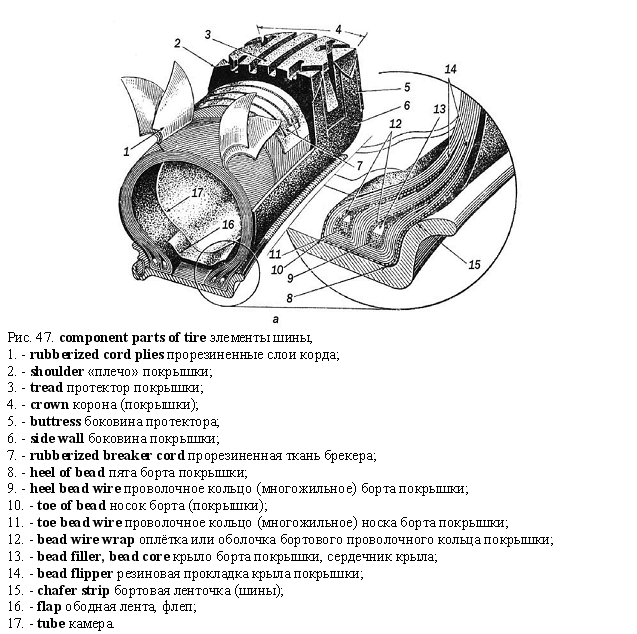 ; радиолампа; воен. гильза
- tube bend
- tube cleaner
- tube closing plug
- tube clip
- tube connection
- tube conveyer
- tube cutoff machine
- tube extractor
- tube extrusion
- tube ferrule
- tube fittings
- tube gage
- tube heat exchanger
- tube joint
- tube leakage
- tube mandrel
- tube micrometer
- tube nozzle
- tube nut
- tube paint
- tube plate
- tube railway
- tube riffles forming
- tube rod
- tube rolling
- tube saw
- tube shell
- tube shield
- tube space
- tube steel
- tube turn
- tube-type oil cooler
- tube-type radiator
- tube valve
- tube vice
- tube vise
- tube wall
- tube welding
- tube wrench
- air tube- aspirating tube - bend a tube
; радиолампа; воен. гильза
- tube bend
- tube cleaner
- tube closing plug
- tube clip
- tube connection
- tube conveyer
- tube cutoff machine
- tube extractor
- tube extrusion
- tube ferrule
- tube fittings
- tube gage
- tube heat exchanger
- tube joint
- tube leakage
- tube mandrel
- tube micrometer
- tube nozzle
- tube nut
- tube paint
- tube plate
- tube railway
- tube riffles forming
- tube rod
- tube rolling
- tube saw
- tube shell
- tube shield
- tube space
- tube steel
- tube turn
- tube-type oil cooler
- tube-type radiator
- tube valve
- tube vice
- tube vise
- tube wall
- tube welding
- tube wrench
- air tube- aspirating tube - bend a tube
См. также в других словарях:
Maud Gage Baum — L. Frank and Maud Gage Baum in Egypt in 1906 Maud Gage Baum (March 27, 1861 – March 6, 1953) was the wife of L. Frank Baum. Her mother was the suffragist Matilda Joslyn Gage. In her early life, she attended a boys high school and was raised to be … Wikipedia
Experimental musical instrument — Gage Averill playing an experimental hydraulophone pipe organ made from a piece of sewer drainage pipe and plumbing fittings in 2006 An experimental musical instrument (or custom made instrument) is a musical instrument that modifies or extends… … Wikipedia
Missouri River — Coordinates: 38°48′49″N 90°07′11″W / 38.81361°N 90.11972°W / 38.81361; 90.11972 … Wikipedia
San Joaquin River — Coordinates: 38°04′00″N 121°51′04″W / 38.0666667°N 121.85111°W / 38.0666667; 121.85111 … Wikipedia
United States — a republic in the N Western Hemisphere comprising 48 conterminous states, the District of Columbia, and Alaska in North America, and Hawaii in the N Pacific. 267,954,767; conterminous United States, 3,022,387 sq. mi. (7,827,982 sq. km); with… … Universalium
Fox-Wisconsin Waterway — The Fox Wisconsin Waterway is a waterway formed by the Fox and Wisconsin Rivers. First used by European settlers in 1673 during the expedition of Marquette Joliet, it was one of the principal routes used by travelers between the Great Lakes and… … Wikipedia
Larrys Creek — Geobox | River name = Larrys Creek category = Creek image size = 300 image caption = Larrys Creek and the Cogan House Covered Bridge in Cogan House Township, Pennsylvania etymology = Larry Burt, first settler country = United States country state … Wikipedia
Nonconnah Creek — (2008) Nonconnah Creek or the Nonconnah Creek Drainage Canal is a 29.7 mile long (47.8 km)[1] waterway in southwest Tennessee. Contents … Wikipedia
Columbia Slough — Coordinates: 45°38′36″N 122°46′07″W / 45.64333°N 122.76861°W / 45.64333; 122.76861 … Wikipedia
Lost River (Idaho) — There are two rivers in Idaho named Lost , the Big Lost River and the Little Lost River. They are often considered separate streams, but both flow into the same depression and become subterranean, feeding the Snake River Plain Aquifer. The rivers … Wikipedia
Aliso Creek (Orange County) — Not to be confused with Aliso Creek (Los Angeles County). Coordinates: 33°30′38″N 117°45′9″W / 33.51056°N 117.7525°W / 33.51056; … Wikipedia